

Lake Mead and Colorado River Basin Psyops


Colorado River Lower Basin water agreements are again in the news this week (May 2023), but at least 80 percent of it is deception and theater to trick the American people into accepting fallowing of farmland and restrictions on their personal water use. It has severe consequences.
Highlights of This Article
§ Lake Mead water level is intentionally and artificially kept low in spite of record amounts of precipitation and snowmelt in 2023 after 20 years of drought, recently filling most of the reservoirs in California.
§ California, Arizona and Nevada water agencies have replenished their aquifers and reservoirs with massive amounts of Colorado River this winter and spring, far exceeding publicly known allocations with Article 21 water.
§ Biden’s Interior Department and US Bureau of Reclamation’s “historic” agreement is actually a cave in to litigation threats from California and postponing needed long-term water allocation reductions and changes in water rights to 2026.
§ The American people in California and all states that purchase its agricultural products will pay a heavy price from major losses of farmland and food production.
§ The federal government, the lower Colorado basin states, and the deep state are all colluding on the game plan. As usual, greed, control, depopulation and destruction of the US as a strong nation are the motivations. Information warfare (propaganda) is a pre-requisite.
Political Reasons for Low Lake Mead Water Level
There are several political reasons for keeping the Lake Mead water level low or falling. Lake Powell and Lake Mead water levels are the primary indicators of Colorado River Basin status. Management of Colorado River water allocations, the federal role and water rights are based on the Colorado River Compact of 1922, aka Law of the River.
I’ll begin with a little background history.
The Colorado River Basin covers seven states and Mexico and is further divided into upper and lower basins. The dividing line between the two is at Lee Ferry, Az. Each basin was allocated 7.5 million acre-feet (MAF) annually under the Compact. California was entitled to an additional 1 MAF annually in high flow years. Mexico was awarded an additional 1.5 MAF under a 1944 treaty, which is overseen by the International Boundary and Water Commission.
Glen Canyon Dam at Lake Powell is the most southern reservoir for the Upper Basin states of Wyoming, Colorado, Utah, and New Mexico. Down river, Lake Mead is the first primary reservoir for the Lower Basin states of Arizona, Nevada, California and Mexico. Lake Powell supplies water to Lake Mead and Hoover Dam for the Lower Basin. The two dams also operate to produce hydroelectric power and require a certain amount of water in the reservoirs to avoid dead pool status that would incapacitate the turbines.
Because the Law of the River Compact of 1922 did not specify the apportionments for individual states, Arizona initially refused to sign and ratify the agreement out of concern that rapidly growing California would lay claim to most of the lower basins of share of water. After much litigation with California, Arizona eventually signed and ratified the compact in 1944, although conflicts continued until finally settled in 1963 by the US Supreme Court. Arizona receives water under both the Upper and the Lower Basin apportionments, since parts of the state are in both basins.
Pursuant to federal law and the Compact, the US Bureau of Reclamation (USBR is part of the Department of the Interior) manages much of the basins’ water allocations. A 1963 Supreme Court ruling confirmed that Congress designated the Secretary of the Interior as the Water Master for the Lower Basin. Further agreements and court decisions have altered management decisions within the basins.
Because of prolonged drought in the Southwest, Drought Contingency Plans (DCPs) were authorized by Congress in 2019, adding additional curtailments of water deliveries based on specified Lake Mead water levels. On June 14, 2022 USBR called for basin states to conserve an additional 2 to 4 MAF of water annually, beginning in 2023. Colorado River Compact Water basin management agreements, including the DCPs, are due to expire in 2026.
Lake Powell and Lake Mead are the principal indicators of water storage conditions used by the USBR. Downstream reservoirs and the many reservoirs in California, even when full, are not calculated into the water storage availability for allocation purposes.
Nevada draws water directly from Lake Mead via the Las Vegas Wash and drainage devises, but Arizona and California water districts draw water from downriver sites and reservoirs. The California Aqueduct is supplied water from Parker Dam at Lake Havasu, which remains full at all times. Arizona has a diverse portfolio of water supplies. Colorado River water sources include the Central Arizona Project at Mohave Reservoir and mainstream diversions around La Paz and Yuma before the river flows into the American Canal to supply Imperial and Coachella Valleys in California.
Colorado River water is delivered to Mexico at Morelos Dam, located 1.1 downstream from the junction of the California-Baja California border and the river. The eastern half of the dam lies inside US territory. Mexico receives only about 10 percent of Colorado River water and natural river flow rarely reaches the Gulf of California delta.
Precipitation and runoff in the basins are highly variable. Water conditions in the Upper Basin largely depends upon snowmelt. Historical data from 1906 to 2020 reveals that overall, natural flows in the Colorado River Basin averaged about 14.7 MAF annually. However, river flows have declined significantly since 2000, now averaged at approximately 12.5 MAF. Allocations have not changed, which explains why Lake Mead levels drops around 12 feet every year.
Since USBR notified the basins and associated water districts of the need to conserve 2 to 4 MAF annually last summer, the states have been actively negotiating among themselves, in order to arrive at agreements and avoid the USBR imposing new agreements and changes in water rights upon them. The Upper Basin states all believe they already had done enough conservation and that all the reductions must come from the Lower Basin. Arizona and Nevada, who took the first drought reductions due to junior rights, jointly made agreements and proposals which were rejected by California. Because California receives the lion’s share of the Lower Basin allocations, other states claimed California should accept the largest reduction. California defended their water rights and allocations without any restrictions until now.
The Lower Basin’s 7.5 MAF was apportioned in 1928 as follows: 4.4 MAF to California, 2.8 MAF to Arizona, and 300,000 AF to Nevada, with the states to divide any surplus waters among them.
Due to the Colorado Basins’ large water storage projects, water users are able to store as much as 60 MAF, or about four times the Colorado River’s annual flows. The storage and operations at the two largest dams, Glen Canyon Dam and Hoover Dam, receive considerable attention. Glen Canyon Dam, completed in 1963, serves as the linchpin for Upper Basin storage and regulates flows from the Upper Basin to the Lower Basin, pursuant to the Colorado River Compact. It also generates approximately 3640 GW hours of electricity per year.
In the Lower Basin, Hoover Dam, completed in 1936, provides a large amount of storage and generates about 4 billion kilowatts of electricity per year for customers in California, Arizona, and Nevada. Also important for Lower Basin operations is the Davis Dam at Lake Mohave, 70 miles downstream from Hoover Dam, which regulates flows to Mexico under the 1944 treaty. Parker Dam at Lake Havasu impounds water for diversion into the Colorado River Aqueduct, thereby allowing delivery of water to urban areas in Southern California.
The Central Arizona Project (CAP) allows water for diversion to users in Arizona. Yuma could not exist without Colorado River water and its diversions from Imperial Dam. Located on the Arizona-California border, Imperial Dam also diverts Colorado River water to the All American Canal for use in California’s Imperial and Coachella Valleys.
Tribal Water Rights
Except from a Tribal Policy Brief - There are 30 federally recognized tribes in the Colorado River Basin. Twenty-two of these tribes have recognized rights to use 3.2 million-acre feet (maf) of Colorado River system water annually, or approximately 22 to 26 percent of the Basin’s average annual water supply. In addition, 12 of the tribes have unresolved water rights claims, which will likely increase the overall volume of tribal water rights in the Basin. Under the Upper Colorado River Basin Compact and the U.S. Supreme Court’s decree in Arizona v. California, all tribal water uses are counted against the apportionments made to the states. Tribes’ rights are generally senior to state law-based water rights.
Currently, many tribes are not fully using their recognized rights for several reasons, including lack of necessary infrastructure and funding; antiquated and inefficient delivery systems; and constraints on off-reservation use. Meanwhile, existing uses of Basin water already exceed reliable supplies. With tribes planning to fully develop and use their water rights, 4 other water users in the Basin are concerned about how the expanded development of tribal water rights can be integrated with existing and future non‐Indian uses of Basin water.
Back to political objectives of low water levels in Lake Mead
Since the adoption of the 2007 Interim Guidelines by USBR, operations of the Hoover and Glen Canyon Dams have been tied to specific pool elevations at Lake Mead and Lake Powell. For Lake Mead, the first level of shortage triggers decreased allocations made to Arizona, Nevada and Mexico if the pool level falls below 1,075 feet. The Drought Contingency Plans enacted in 2019 overlay additional curtailments in both reservoirs beyond those established in 2007.
Thus, a low level of water in Lake Mead immediately creates a sense of scarcity, regardless of how much water is stored in hundreds of other California reservoirs and underground aquifers. This is used to demand conservation measures, fallowing of agricultural land, reduced personal consumption, and higher prices of water.
Every water district in the Lower Basin has been making contingency plans and storing water for the last 20 years. Few Americans not involved in the water industry realize just how many reservoirs there are. For example, in Los Angeles County there are over 110 reservoirs. It becomes a shell game of hiding water, later to be sold to the highest bidder. The media rarely, if ever, mentions the other storage sources of water beyond a crisis condition slowly but surely occurring at Lake Mead.
Agriculture uses about 80 percent of developed water, or 50 percent of all water resources in California. Food obviously cannot be grown without water. In the past few years, even farmers with senior rights have not received their normal allocations. Farmers are being paid to fallow their land. With drought, ground water drilling and pumping has rapidly accelerated, resulting in aquifers being overdrawn, subsidence, and drying up of wells. The consequences of water shortages cause food shortages and economic damages to the entire agriculture industry and workers. Because California is the largest producer of fruit, nuts and vegetables, food shortages will eventually extend to the entire nation.
Water scarcity and drought is a key aspect of convincing Americans about climate change and global warming, justifying less consumption and changes in many aspects of life and commerce. The long-term decline of Colorado River flow and capacity of Lake Mead has been blamed mostly on global warming. That narrative ignores the fact that the river has been over-allocated since The Compact of 1922. Federal projections of Lake Mead and Lake Powell approaching dead pool levels is used to pressure water districts water agencies in all seven states to drastically cut back on water use.
Water scarcity effects economically disadvantaged people the most. At least a million Californian’s do not have access to clean drinking water. Water bills are going unpaid due to rising prices and the utilities have been shutting off water to homes. Over 1500 shallow wells went dry in rural California last year. Higher water prices are adding to industrial and farming costs, thus contributing to inflation. Water has become an expensive essential commodity instead of a natural resource shared equitably by all people.
The threat of water scarcity creates fear, stress and conflict. Stressed, worried people are more vulnerable to manipulation and being fooled by the government and the media. Fear breeds collective fear. It also exacerbates conflicts between growers, residential uses and environmentalists in a divide and conquer mentality. From the beginning, the other basin six states have suspected that California plots to appropriate more than its fair share of the pater at their expense.
Weakening of California, and thus the United States, is part of the New World Order plan by the UN, the WEF, the Council on Foreign Relations (Trilateral Commission) and the Deep State. Read my technocracy articles in Search for Truth News if you have not been informed about that.
There is no real scarcity of water, although efficient use of water and conservation measures in arid and semi-arid climates and modern agricultural methods deserve to be standard operating procedures. The scarcity is in fact a re-distribution of water resources to the rich and powerful, who have large estates and corporate farms with massive consumption of water while others go without.
Low water levels at Lake Mead is a simplistic way of documenting scarcity. Continue reading about how much water California water districts such as Metropolitan Water District actually owns, control and sell. What follows could be shocking for the average unsuspecting citizen to realize.
Metropolitan Water District and Article 21 Water
Metropolitan Water District (MWD) is such a big player in California water politics, the management of Colorado River water resources cannot be fully appreciated without digging into the powerful control of MWD. In fact, it should be considered another state water department, comparable to the strengths of the Departments of Water Resources (DWR) and the State Water Resources Control Board (SWRCB).
MWD is a water wholesaler and has no retail customers. Its members include 14 cities, 11 municipal water districts, and the Los Angeles Department of Water and Power. It is considered a public cooperative state agency with municipal responsibilities. It contracts with every California entity that receives Colorado River water. The Colorado River Aqueduct that conveys Colorado River is owned and operated by MWD. MWD paid for nearly the full cost to build Parker Dam at Lake Havasu and half of the hydroelectric power generated there is used to pump water along that aqueduct.
MWD’s other major water source is the State Water Project. It provided funding and engineering research for other structures including Hoover Dam, and pending structures such as the Delta Conveyance Project and Sites Reservoir. It funds water districts to pay farmers to fallow agricultural land in Palo Verde, Imperial and Coachella Valleys.
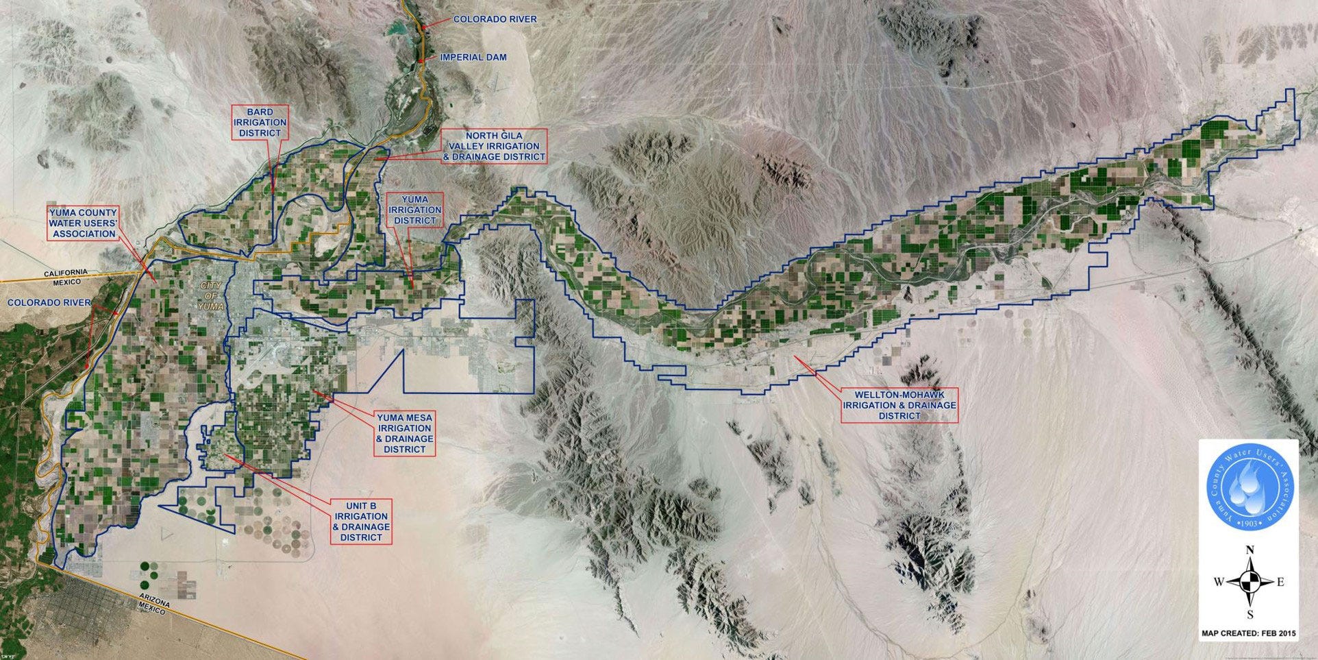
MWD banks unused water in multiple reservoirs, including Lake Mead, for later use. It has bought up large tracts of agricultural land, where it can infuse aquifers for storage or lease it back to farmers. For example, it is the largest land owner in Palo Verde Valley with 22,000 acres and has a 35-year agreement there paying farmers to fallow up to 28 percent of the land. It has a seven-year contract with Bard Water District. Bard Water District is located in the southeastern corner of California bordering Yuma, Arizona. Colorado River water is diverted from the All American Canal into the Bard Water District to irrigate approximately 7,120 acres for agriculture purposes. The canal runs along the north side of Bard Water District.
MWD banks unused water in Arizona as well when its California reservoirs are full. At the end of 2021, MWD had a whopping 8.2 MAF in storage. Next, I’ll explain the Article 21 Water, which facilitates MWD, Imperial Irrigation District and Yuma County to accumulate enormous water storage with little public accounting.
Article 21 Water Rights are omitted from most public documents. I began to suspect shady operations when just about all California reservoir water levels were rapidly rising from the 19 massive atmospheric river series and heavy snowpack EXCEPT for Lake Mead. My suspicions were confirmed when a friend who lives part time near the Colorado River south of Parker Dam said the river and canals there and south at least as far as Blyth were flowing at capacity. Hmmmm…. That meant unaccounted amounts of water according to the allocations we read about was being released, keeping Lake Mead low at current levels.
Press releases from the DWR in March and April 2023 forecasted a return to 100 percent of water deliveries to all of their 29 public water agencies with reservoirs nearing capacities even before snowmelt occurs. The last time SWP allocated 100 percent was in 2006. The goal was to move and store as much water as possible via Article 21 water. Article 21 water does not count toward SWP allocation amounts.
Between March 22 and April 20, SWP delivered 228,000 acre feet (af) of Article 21 water to local water agencies, with an additional 37,000 af planned for the following week. SWP was making the extra water available to contractors that have the ability to take delivery in their own system, including through groundwater recharge. Metropolitan, SWP’s largest contractor, requested Article 21 water in late March to refill Diamond Valley Lake and other facilities.
Contractors must take the water when it is offered on a weekly basis and store it in their own system. There are different agreements to store it outside of their service area. Contractors cover the cost of delivery but do not pay for the water.
DWR staff explained to Water Commissioners in April 2018 how Article 21 water is managed. The maximum allocated water is Table A water delivered under contract to 29 SWP water agencies. Article 21 is non-Table A excess water that becomes available on an intermittent basis. It is also referred to as wet weather water when SWP has no storage remaining following heavy precipitation. Contractors are not allowed to defer Table A allocations for later because they are getting Article 21 water. Kern County Water Agency and MWD have been the top contractors taking delivery of Article 21 water.
SWP and the USBR operate dams and conveyance systems jointly, so the same probably applies to Colorado River excess water. In April, USBR reported that the unregulated Probable Maximum Inflow to Lake Powell was 17.86 MAF, or 186 percent of average.
Examination of water levels at Lake Mead reveal it remained at a consistent level all winter and spring, rising only when Glen Canyon Dam released a one-time 9.50 high volume amount from Lake Powell at the end of April, thereby raising the Lake Mead level by about 2.5 feet to 1,049.74 ft. This was intended to clear accumulated sediment back onto the beaches along the river. Lake Mead has been very slowly rising in May from snowmelt; the level on 5/27/23 was 1053.55 ft.
Average daily water releases from Hoover Dam from March through May ranged from 13,600 to 17,900 cfs. Meanwhile, the Lake Mead elevation level changed very little, demonstrating that the water masters were delivering water to the contractors to fill their reservoirs and recharge ground water, rather than raise the lake level from above average inflow. However, the public is repeatedly told that the Colorado Basin remains in drought conditions, justifying drastic conservation measures and proving the existence of climate change. El Nino’s arrival this summer will bring another wet winter, but does not dampen drought condition claims by the media.
That is big Deception # 1. Next is Deception #2.
The Deceptive Agreement Between Lower Basin States and USBR
The federal government, Department of Interior and USBR, have led multiple efforts to improve the basins water supply, resulting in collaborative agreements in 2003, 2007 and the 2019 drought contingency plans. Due to ongoing concerns, on June 14, 2022, USBR called for basin states to conserve an additional 2 to 4 MAF of water annually beginning in 2023.
The Upper Basin states demanded that the Lower Basin states take all The USBR curtailments in the belief they had done enough already. Arizona and Nevada were curtailed in 2022 and proposed further adjustments beginning 2023. California rejected all proposals that involved any cutbacks in supply for California, even though it is the largest consumer of Colorado River water.
Negotiations have been ongoing for the past year between Lower Basin states and the USBR. The states’ goal was to avoid any unilaterally imposed curtailments of water delivery by the USBR. Options discussed included retaining the system of senior and junior rights versus making equal cuts across the board. The possibility of renewing versus amending basin management agreements due to expire in 2026 took center seat in the arguments.
In April 2023, the USBR published a draft environmental impact statement with the two action alternatives in which the three Lower Basin states would be cutback on water deliveries in 2024-2026.
On May 22, 2023, the Department of Interior announced a consensus-based proposal in which the three Lower Basin states will conserve a total of 3 MAF prior to 2026. NOT annually as before. The draft EIR was dropped and the USBR agreed to pay the water districts a total $1.2 billion dollars for use to compensate contractors and farmers for fallowing agricultural land. The announcement did not specify allocation of curtailments, nor how it is tied to Lake Mead elevations. The agreement again postpones definitive long-term actions to protect the Lower Basin water status. The “agreement” is in truth a proposal, under consideration for final approval by the Interior Department.
In subsequent commentary, each of the key negotiators publicly expressed relief that the agreement avoided the very real threats of litigation by California. Biden called the agreement a historic accomplishment, even though the federal government had just caved to California’s demands. According to Politico, Gov. Newson met multiple times with Gov. Katie Hobbs from Arizona. Newsom stated that the election of Hobbs enabled the new agreement.
Again, the public is deceived about what really happened and its long-term consequences.
Long Term Consequences
· The Deep State clearly retains control so far over the Colorado Lower Basin and California water politics.
· Transparency of water management is nearly non-existent, as in smoke and mirrors.
· The Colorado River remains over-allocated for another three years at least.
· Agriculture and food production in California continues to be suppressed, which will affect many individual lives and health, the California economy, and the nation.
· The corporate elites and large water districts benefit from the perception of water scarcity, resulting in high water prices as a commodity.
· Water supply equity and clean drinking water access for all remains a distant goal.