California Atmospheric Rivers and Bomb Cyclones, Part 1
The Good, The Bad, and The Unnatural

The brutal impacts of the successive storms battering California in late Dec. 2022 through mid-January 2023 is a mixed bag of good, bad and unnatural events, ranging from diminishing severe drought conditions to over 20 deaths and massive damage from flooding and high winds. Significant refilling of the reservoirs in northern and central regions, a heavy 16-foot snowpack, aquifer replenishing, and flushing of the rivers and delta for fish survival is good. It is good that most Californians have woken up to the need to capture and store stormwater. But there is a long way to go to repair drought impacts.
Bridges, roads, homes, businesses, cars, schools, power grid, swamped farmland, levee breaks, and tree damage caused an estimated $1 billion dollars in northern and central California coastal regions. Catastrophic flooding from 10 to 20 inches of torrential rain, mudslides from denuded forests from past wildfires, sinkholes, widespread, prolonged power outages suffered by hundreds of thousands of Californians, and mass evacuations was staggering. Some regions received a year’s worth of rain in just two to 3 weeks.
Forecasters didn’t see the storms coming, so people have questioned the apparent meteorological unreliability. Usually, the National Oceanic and Atmospheric Administration’s (NOAA) Climate Prediction Center (CPC) can predict seasonal precipitation and temperature up to 13 months in advance. As late as November and early December, the CPC saw no change in the persistent California dryness related to El Nina for the next 5 months.
Basic Weather Science
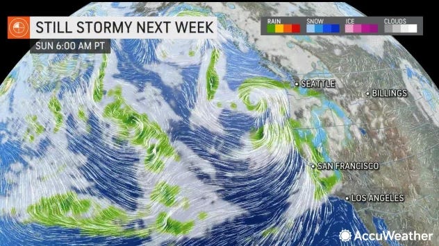
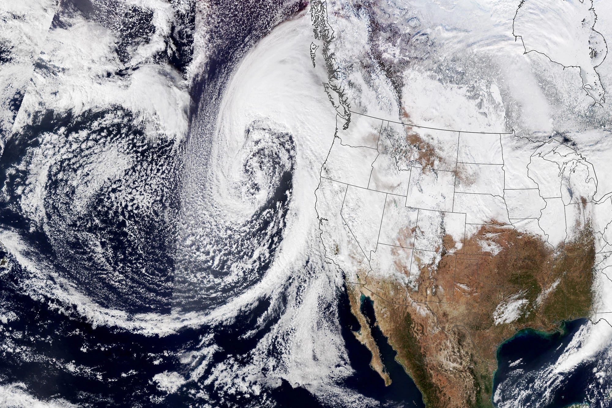
A relentless series of nine bomb cyclones and atmospheric river storms struck northern and central California between Dec 26th and January 21st. These are a very unusual events, particularly because of the number of storms in persistent La Nina conditions that usually maintains dry weather on the west coast. Earth science explains how storms form and are transported across the globe and why it was not forecasted by meteorologists.
Wind Directions and Ocean Temperatures
Wind is caused by temperature and atmospheric pressure differences along with the Earth’s rotation. Wind typically moves from areas of high pressure to areas of low pressure. Wind moves counter clockwise in low pressure systems and clockwise in high pressure systems. There are four main wind patterns: Trade Winds, Prevailing Westerlies, Polar Easterlies and the Jet Stream. The first three types occur in 30 degree bands of Earth’s latitude.
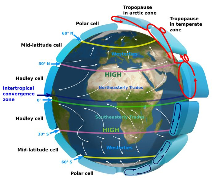
Trade winds are air currents that blow east to west up to 30 degrees north and south of the equator, because of how Earth rotates on its axis and temperatures of the sea and air. They begin as warm, moist air at the equator that rises in the atmosphere but sink as they cool and release moisture as they move toward the poles in a cycle called the Hadley cell. Because the Earth rotates faster at the larger surface of the equator than the poles, the wind curves to the west in the Northern Hemisphere and curves to the east in the Southern Hemisphere, called the Coriolis Effect. There is almost no wind at the equator in an area called the doldrums. The trade winds can steer storms as will be described below.
Prevailing winds from west to east are generally in the 30 to 60 degree latitude belts. This is air trapped between the polar easterlies and the trade winds and moves in a clockwise motion from west to east.
Cold air at the poles between 60 and 90 degrees latitude heats up, expands and rises as it moves toward the equator, then cycles back in a counterclockwise loop. These are called the Polar Easterlies, moving east to west.

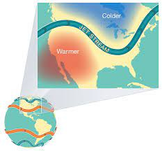
The Jet Stream results from the collision between the Polar Easterlies (high pressure air) and the Prevailing Westerlies (lower pressure) forming a fast, powerful wind moving from the west to the east. It moves in a swirl pattern and changes on a daily basis. It is responsible for moving weather systems.
Intense heat at the equator warms the ocean water and the air. The warm, moist air in the tropics then rises from the West around Hawaii in the Pacific into the atmosphere, forming clouds, rain and storms in tropical regions. The air dries and cools as it rains and descends in the East back to the surface, where it is blown towards South America by higher altitude winds. This brings drier weather and completes the Hadley cell cycle.
Normally, the tropical western Pacific is warm and wet with low a low-pressure system. The eastern Pacific is cooler and dry under a high-pressure system. This creates a pressure gradient from east to west, causing surface air to move east to west, or from high to low pressure. Higher up in the atmosphere, west to east winds complete the circulation cycle. These are the jet streams, which are narrow currents of strong westerly winds in the troposphere. Trade winds are predominately easterly winds moving closer to the surface.
Jet Streams
Jet streams are narrow bands of strong wind that generally blow from west to east all across the globe at high altitudes. Earth has four primary jet streams: two polar jet streams, near the north and south poles, and two subtropical jet streams closer to the equator. Jet streams form when warm air masses meet cold air masses in the atmosphere. So when Earth’s warmer air masses meet cooler air masses, the warmer air rises up higher in the atmosphere while cooler air sinks down to replace the warm air. This movement creates an air current, or wind.
On average, jet streams move at about 110 miles per hour. But dramatic temperature differences between the warm and cool air masses can cause jet streams to move at much higher speeds — 250 miles per hour or faster. Speeds this high usually happen in polar jet streams in the winter time. Jet streams are located about five to nine miles above Earth’s surface in the mid to upper troposphere. Pressure system changes and atmospheric heating can create bulges to the north or south in the jest stream with significant changes in the weather resulting.
Airplanes fly in the mid to upper troposphere. When an airplane flies in a powerful jet stream and they are traveling in the same direction, they can get a boost. That’s why an airplane flying a route from west to east can generally make the trip faster than an airplane traveling the same route east to west. Weather satellites, such as the Geostationary Operational Environmental Satellites-R Series (GOES-R), use infrared radiation to detect water vapor in the atmosphere. With this technology, meteorologists can detect the location of the jet streams.
El Nino/Southern Oscillation (ENSO)
ENSO Blog is written by contractors to NOAA’s Climate Prediction Center about monitoring and forecasting El Nino and La Nina impacts on climate and weather. The forecasters use NOAA’s new supercomputers to incorporate all the data from multiple sources. Because of Earth’ rotation on its axis, trade winds at the equator blow from east to west, pushing and warming water towards the west side of most ocean basins. The blog explains how equatorial, tropical Pacific sea temperatures and atmospheric responses create El Nino and La Nina conditions (ENSO) that affect North and South America, Africa and Asia in a loop called the Walker Circulation.
The Walker Circulation patterns are caused by sharp contrasts in sea surface temperatures across the Pacific Ocean. The western tropical Pacific contains the warmest regions, called the Western Pacific Warm Pool, where sea surface temperatures are above 28 degrees Celsius. In contrast, the eastern equatorial Pacific has relatively cold ocean surface temperatures by 5 to 10 degrees, extending from the South American coast westward. ENSO events are strongest in the northern hemisphere during winter months, as seasonal patterns. Temperature contrasts between land and water amplify the circulation.
The lower part of the loop flows east to west across much of the sea surface in the tropics and the upper part blows west to east at higher altitudes as described in the wind types section of this paper . Rising air in the west and sinking air in the east connect the flow in one big, continuous loop.
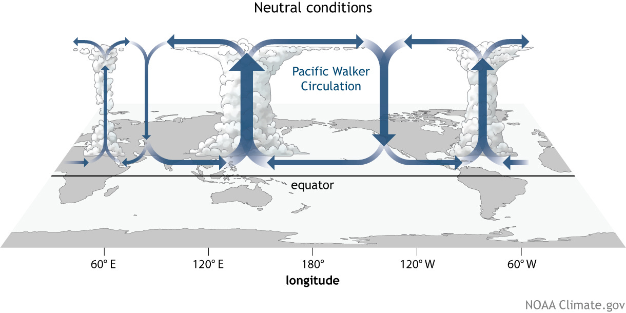
In neutral conditions, air over warm water rises in the west and air over cooler water in the east dries and settles near the surface. In meteorological terms, the West Pacific is near southern Asia in the Eastern Hemisphere while the East Pacific is near the Americas in the Western Hemisphere.
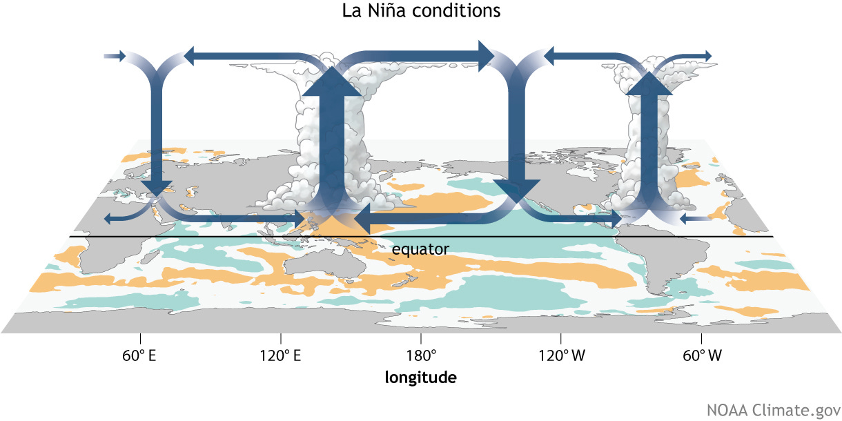
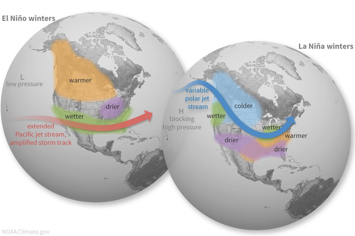
In La Nina conditions the Walker Circulation loops are strengthened, where waters in the West Pacific are warmer than normal and waters in the East Pacific are colder. This leads to above-average rainfall over the Maritime Continent (Southeast Asia, Indonesia) and less rainfall over the Eastern Pacific (Pacific Coast of the Americas from southern California to northern Peru). Moreover, it affects jet stream and pressure system patterns as seen in the images below.
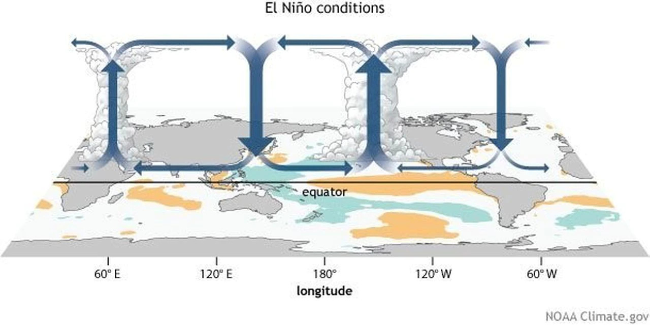
In El Nino conditions, the Walker Circulation is reversed, changing the rainfall amounts. The warm waters usually in the western Pacific move eastward, bringing along with it heavier precipitation. The east-west pressure differences across the Pacific are reduced along with the easterly trade winds. The usual rising, moist air over South America is replaced by a sinking region resulting in less rainfall and enhanced rainfall over the central Pacific Ocean and even parts of equatorial eastern Africa.
Atmospheric Rivers
Atmospheric rivers are long narrow bands of concentrated water vapor that produce heavy precipitation. They can hold as much water as in the Amazon River. They begin in the warm waters of the tropical Pacific, where moisture evaporates into the air. They are nicknamed the Pineapple Express transportation of precipitation. Atmospheric rivers were augmented and merged with bomb cyclones in the recent parade of storms marching over the Pacific onto California as an overlapping phenomena.
Bomb Cyclones
Hurricanes, cyclones and typhoons are all rotating storm systems with winds exceeding 119km/h (74 mph). The name and type differs based on the location of the storm. A bomb cyclone is a storm whose pressure rapidly falls rapidly over a 24 hour period. The term refers more to the speed at which the storm forms than its absolute strength, although there are correlations between drops in pressure and storm strength.
Bomb cyclones form when air near the sea surface rises quickly into the atmosphere over 24 hours, triggering a sudden drop in barometric pressure when the air is rising faster at the top than it can be replaced at the bottom. This causes the pressure to drop, yielding a strong storm with very strong winds, heavy precipitation and eye-like features in the middle. As the air rises, wind spirals form at the bottom of the storm. Meteorologists call this process bombogenesis. Mid-latitude cyclones can form atmospheric rivers, and can also generate them.
Unlike hurricanes or other storms where the center has the strongest winds, bomb cyclones can generate the worst weather at their edges. Also unlike hurricanes, bomb cyclones arise in mid-latitudes, where warm and cold fronts collide in late fall to early spring instead of summer. Because they are low pressure systems, they spiral in a counter-clockwise direction, rather than clockwise hurricanes. Several conditions are needed for a tropical cyclone to form: High sea temperatures of at least 27°C and converging winds near the ocean surface, forcing air to rise and form storm clouds.
How Hurricanes and Cyclones Are Formed
From The Scientific American, Why do hurricanes hit the East Coast of the US but never the West Coast? Oct 21, 1999.
Chris W. Landsea is a researcher at the Atlantic Oceanographic and Meteorological Laboratory/Hurricane Research Division of the National Oceanic and Atmospheric Administration (NOAA), located in Miami, Fla. He replies:
"Hurricanes form both in the Atlantic basin, to the east of the continental U.S. (that is, in the Atlantic Ocean, the Gulf of Mexico and the Caribbean Sea), and in the Northeast Pacific basin, to the west of the U.S. The hurricanes in the Northeast Pacific almost never hit the U.S., however, whereas the ones in the Atlantic basin strike the U.S. mainland just less than twice a year on average.
"There are two main reasons for this disparity. The first is that hurricanes in the northern hemisphere form at tropical and subtropical latitudes and then tend to move toward the west-northwest. In the Atlantic, such a motion often brings the hurricane into the vicinity of the East Coast of the U.S. In the Northeast Pacific, the same west-northwest track carries hurricanes farther offshore, well away from the U.S. West Coast.
"The second factor is the difference in water temperatures along the U.S. East and West coasts. Along the East Coast, the Gulf Stream provides a source of warm (above 80 degrees Fahrenheit, or 26.5 degrees Celsius) waters, which helps to maintain the hurricane. Along the West Coast, however, ocean-surface temperatures rarely rise above the lower 70s F. (the low 20s C.), even in the middle of summer. Such relatively cool temperatures do not provide enough thermal energy to sustain a hurricane's strength. So the occasional Northeast Pacific hurricane that does track back toward the U.S. encounters the cooler waters of the Pacific, which can quickly reduce the storm's strength."
Kerry Emanuel in the Center for Meteorology and Physical Oceanography at the Massachusetts Institute of Technology expands on the details of hurricane behavior:
"Hurricanes almost always form over ocean water warmer than about 80 degrees F. in a belt of generally east-to-west flow called the trade winds. They move westward with the trade winds and also drift slowly poleward. Eventually, if they last long enough, they will drift poleward far enough to enter the belt of westerly winds that prevails in middle latitudes. When this happens, the hurricanes 'recurve' toward the east and thereafter follow paths that are generally both eastward and poleward.
"In the Atlantic region, hurricanes form anywhere from the tropical central Atlantic to the Gulf of Mexico. Those that form in the central Atlantic and Caribbean region usually start off moving westward; when they recurve, they may strike the North American mainland. Some of the storms that begin in the Gulf of Mexico may move poleward and eastward right from their inception.
"In the eastern Pacific region, one has to go all the way down to the central Mexico coastline to find water warm enough to sustain hurricanes. This warm water lies well within the belt of easterly winds, so almost all the storms that form there move away from the coast, toward the west. By the time those storms recurve, they are usually many thousands of kilometers west of the coast of North America.
"A few storms recurve right next to the coast. Some of these make it as far north as Baja California and can strike land with hurricane-force winds. But to make it all the way to the U.S. West Coast, the storms have to traverse a long stretch of ocean water that is far too cold to sustain hurricanes. Occasionally, tropical storms do strike coastal southern California. By the time they do, they have lost their hurricane-force winds, although they may still bring with them very heavy rainfall that can cause extensive flooding.
"Essentially, the very cold water that upwells off the California coast and gives coastal California such a cool, benign climate also protects it from hurricanes. Real-time maps showing the distribution of the potential intensity of hurricanes clearly show the various regions worldwide that can sustain hurricanes.